What is a watershed?
A watershed is the land area that channels rainfall and snowmelt into creeks, streams, and rivers, then eventually to outflow points, such as reservoirs, bays, and the ocean.
Water from creeks and streams flows from higher ground to rivers that eventually wind up in a larger body of water.
In Costa Rica, there are 3 major drainage basins, 34 watersheds and two major aquifers. The Rio Nosara Watershed (outlined in red on the map below), empties into the Pacific Ocean, specifically emptying directly into the marine protected area at the Ostional National Wildlife Refuge.

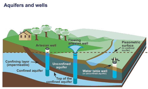
What is an aquifer?
Aquifers are underground reservoirs. These reservoirs are a body of porous rock/sediment saturated with groundwater. The groundwater enters via precipitation that seeps through the soil; it can move through the aquifer and resurface through springs and wells.
There are two types of aquifers:
1. Confined Aquifers – layer of impenetrable rock/clay above them
2. Unconfined Aquifers – lie below a permeable layer of soil
The two major aquifers in Costa Rica store 90% of the municipal, industrial, and agricultural water supply needs of Costa Rica. These aquifers are found in the central and northern part of Costa Rica; they’re called the Upper and Lower Colima, spreading approximately 170 sq. km and 230 sq. km, respectively. The Upper Colima receives a large part of its recharge from smaller aquifers and rain infiltration, while the Lower Colima is recharged from the Upper Colima and from surface water.
Where does drinking water come from?
A significant amount of drinking water comes from aquifers. To access this water, a well must be created by drilling a hole that reaches the aquifer. Wells are man-made points of discharge; aquifers naturally discharge at springs and in wetlands.
Some homes and businesses run off private wells, but the majority of Nosara runs off water provided by ASADA, which is run by volunteers. In Playa Pelada and Playa Guiones, water is occasionally rationed due to shortages (especially February-April) and many residents have therefore added storage tanks. ASADA volunteers are continuously working to improve the system and add new wells.
What are some causes of water pollution?
When a watershed has impervious surfaces (hard surfaces such as paved roads, buildings, other structures that prevent infiltration) water runs quickly and can cause erosion and overflow, possibly leading to flooding.
As water flows over land in the watershed, pollutants are picked up. It either flows directly into the water or infiltrates the ground; this groundwater eventually seeps into the nearest streams and into the ocean.
When water infiltrates deeply, it can contaminate aquifers that provide drinking water.
There are two types of pollution
Point Source pollution comes from a specific source, leak, or drain
Non-point source pollution comes from or released over a larger area
Common sources of water pollution include sewage or other wastewater, leaks from sewers or landfills, oil spills and leaks, agriculture, forestry, marinas and boating, roads, highways, bridges, and urban areas.
By learning more about local water pollution,
we can learn how to reduce our negative impact!
The community took notice of water pollution at the Beaches of Nosara and we've been monitoring water quality since.
Our Water Quality program is working to identify science- and nature-based solutions to improve water quality and ensure clean drinking and recreational water for the future of Nosara.
Check out our project page to read more about what we've learned so far and what you can do to help!
References
Rico. Mapping Costa Rica's Aquifers. QCostaRica. 22 February 2018. Available at: https://qcostarica.com/mapping-costa-ricas-aquifers/
Asociacion Civica de Nosara. “Elaboración del Diagnóstico Hidrogeológico (Fase 1) del Proyecto Estudios Hidrogeológicos para los Planes Reguladores" Noviembre 2018. Disponible en https://www.nosaracivicassociation.com/PDF/InformeFaseIHidrogeologicoFinalv2.pdf
USGS. Aquifers and Wells. Available at https://www.usgs.gov/media/images/aquifers-and-wells
National Geographic. Point Source vs Non-point Sources of Pollution. Available at https://www.nationalgeographic.org/encyclopedia/point-source-and-nonpoint-sources-pollution/
Filter Water. Water Pollution and Causes of Water Pollution. Available at https://www.filterwater.com/t-articles.water-pollution.aspx
Nosara Living. https://nosaraliving.com/utilities/water/